Sabah Adventure Challenge Race Report : Longest Day 1
The phone alarm went off at 4.45am sharp and it was shut off almost immediately. Laying down in bed covered by the comforter and warmed by the room's heater, i inhaled cold air. Despite wearing a light jacket over a t-shirt to sleep, i still felt cold. I woke wifey up and I was not sure how she will be feeling that day. It will be her longest day racing.
Camelbak Octane 18X packed and ready
That was an eerie silence as I mix the Hammer Nutrition Perpetuem powder to be taken as breakfast. One pack/serving provides 270kcal in 20oz water. Cafe Latte was the choice of the day.
Easy drinking liquid food
Perpetuem has Carnosine, (also in HEED, and Recoverite), is both a performance aid (a superb acid buffer) and a premium general health nutrient (multiple free-radical scavenging and anti-glycation antioxidant). I've experimented with this during 42km Hash Challenge and it worked superbly with my system. No bloating and GI issues. I am not expecting any problem going 100% on Hammer for his race.
Yummeh!
I shared half of the fuel with wifey. Doesn't make sense to eat myself and not share...right?
While wifey prefer to lay down and drink...
We kitted up at 6am and it was last minute item checking to make sure all race items are accounted for. One of the important thing for me is actually the electronic tracking devices - I always have the fear that it suddenly doesn't work...
OK, all system go!
We race today Darling. Please don't *peace* sign...put on your Game On Face.
The race start for Day 1 was at the Park's reception area. I was impressed with the organised chaos happening as Aman directed everyone to their station. It was Go-Go-Go from then onwards!
At least 10 4WD mobilised for the race
Race Start!
7:55 and the horn went off. It was chaos as the strong competitors dash up the 20Deg gradient slope and disappeared into Mesilau trail. Myself, wifey and Bandit took it easy and stayed at the back of the pack. How did I feel? Nervous. Seriously.
It marked the start of a 75km race over the next 2.5 days. Day 1 would not be easy and if the race and course directors can tell you that during the race briefing just 10hours ago, you better believe it. I estimated me and wifey to be able to cover the first 6km in 3-hours, top. That is moving 1km/30mins. That is slower than when we walked the dogs at home. At 30:00 pace, walking the dogs at 10:00 pace is a run!
High spirit. Way to go babe!
Wifey took a risk by wearing the Skechers GoTrail that i bought for her a week before. I have confidence with the shoe not giving problems because I had good experience with it the very first time i wore it. In fact, short of one shoe that i wore for a race fresh out of box, I've never had any issues. Perhaps, very lucky myself. :)
Pink GoTrail for the babe
Mesilau trail is beautiful. It is 2km longer compared to Timpohon and less "stairs" to climb. The trail made that up with one extra peak (to the ridge) you have to climb before tackling the major last climb. By all mean, it is not an easier route for beginner, but will delight seasoned hiker.
Beautiful - much more beautiful than Timpohon
I tried to make it a point to take photo of each hut we reached. It is one way to document the journey by placing known objects along the way. There is a functioning toilet next/nearby each hut and they are generally cleaner than those along Timpohon (as less people attempt Kinabalu via Mesilau).
KM1, Schima. The chap in the photo is not a racer. From the tag he wore, he is one of the park guide. Not sure what he was doing there though.
We came to a clearing soon after the first hut and it opened up beautifully to the view of Kinabalu. You can see Tunku Abdul Rahman Peak (left) and Donkey's Ear (right) clearly in the photo below.
Thumbs up! OK. Time to move!
Vegetation along the way gets more sparse and trees shorter. It became very apparent once we reached the ridge with nothing more than 3meters in height. Temperature was at a bearable 20degC at about 2200m asl.
Add caption
I took two Perpetuem Solids every hour. The Solids will remind you of the malt sweets we used to take when growing up. It was easy to bite and actually tasted good. Along with the solid, i took three Endurolytes and one Gel. The food were taken with two or three sip of Hammer HEED in my Camelbak bladder. That gave me the 290kcal/hour and the 500mg electrolytes I needed. I am to adjust as the race goes on, as no two athletes need will be the same. I am also moving at a slower pace, which meant my energy expenditure is less as well.
You see how I love my coffee?
Wifey also took the Hammer Nutrition items. They were bought before the race and I've calculated similar requirement for her.
Hammer Gel in Vanilla
My intention was to fully experiment on the fuel while allowing Wifey to see what suits her. As I am used to train on empty and race with minimal food, It will be interesting to see how things play out as the hours goes by.
Looking strong
The ridge
We reached the ridge about 2hours later and unfortunately it was shrouded with clouds and mist. We missed the fantastic view of the mountain from this vantage point. As you can see from the photo above (do click on the image for larger view), the red speck is wifey and you can picture it in your head how great the view was for me (and not because of her beauty alone - yes, i am corny)
Passing the ridge, it was downhill from there and we reached a small waterfall. This is really something you can only see if you take Mesilau trail. While Timpohon has the Carson Fall, this sight was refreshing. Should had taken a dip there!
Tempting
Immediately after passing the waterfall's hanging bridge, it was climbing again...and It kept going up
Lucky for the walking stick
And UP...
Tired eh?
....and UP....
Every turn awaits you with more climbs...wifey was at the end of the trail. Click photo to enlarge for the panoramic experience
....and, did i say...UP?
Nice view!
It ran into the 3rd hour and we barely covered more than 6km...But i know we are near...
Time to fuel up on 3rd Hour of the race...something different for a change.
...Are we darling?
No we are not!
Yeah, If wifey was any nearer, I would had gotten a smack on my face for asking that question ;-) I took a lot of time photo-documenting the surrounding and saw a whole bunch of Monkey Cups. Must be my lucky day.
Any bigger it will swallow unknown hikers
And just right next to it was some bell-like flowers. :) pretty!
Bet you don't see this when racing eh?
Here is a video commentary of the trail while moving up to Layang-Layang
I know we were near and I know we need to climb up to circa 2800m asl. A check on my Fenix showed we are near. The big climb was finally going to be over.
Another 150m to go (in vertical height). Check the vertical profile for the past 4-hours (that include the 1-hour I switched on the watch before the race, cool eh?)
And then, suddenly, it was a small downhill....and we arrived at Layang-Layang aka KM4 from Timpohon Trail!
There already! I told wifey...But because i said it every 15mins, she don't believe me
The look of relief on Wifey's face, it was priceless...
OK, I take a drink first while you do that thingamagigpanoramicshit (as usual, click to enlarge to s bigger pic)
The guy behind us is a mountain guide...he casually wear only a Crocs-like sandal to climb up. He was amused to see so many people with nothing to do running down Kinabalu in a hurry...
We then started the descent to make up for lost time. Along the way, we bumped into many people making their way up to Kinabalu. Well done all of you!
Layang-Layang Staffs' Quarter. A porter seen washing his face to freshen up in the photo
Coming down through Timpohon gate, we know the distance to be about 4km. Distance markers are better placed at this trail. One has to be careful going down Timpohon due to the big steps that could put a lot of strain to the knees. My advice is to move down slowly and at your own pace.if you are fitter, consider hopping down with each landing in short transient as it will minimise impact further.
The guy in Orange was familiar...
Speaking of coincidence...Remember we saw Khoo in LCCT? Then we found out Khoo stayed in the same Chalet as us the day before...and on Day 1, we bumped into him coming down from Kinabalu. Weather was fantastic that day for the climb up to Low's Peak and I am sure Khoo has many many photos taken! Can't wait to see them.
Aileen patting Khoo's head? Haha!
The rest of the journey down towards Timpohon is pretty much SOP from the two Climbathon we did in 2010 and 2011. We pretty much know what to expect having race up and down this trail a few times. One thing that never failed to awe us was how the local porters carry heavy food items and other items up for a small fee.
No shopping carts here!
I estimated it to be about 30kg. Check the Uncle Porter's Calves! And no fancy shoes!
We exit Timpohon and ran/jog a little to CP2 - the first official CP of the day to where Doc Dev and Pam were waiting. Obviously, we were about the last team ;-)
Thanks Doc Dev. And yes, as usual, we (try to be) happy! If you all noticed, there is a plastic bag (white) on my left side. That is for rubbish.
A little bit of SAC CP stations to set expectations right. It is not a makan/food station. SAC is a self-sufficient race. Racers would need to carry food and water adequate for themselves and do not and should not rely on organisers to provide FOOD. Water are available in 500ml bottle and care should be taken to minimize wastage as to be considerate for others as well. This is also to control the amount of rubbish generated.
Basic, but sufficient. Pam and Doc Dev manning CP2.
It was the first time wifey used the walking stick extensively and inexperienced has taught her how to use the stick in a better manner so small injuries such as blisters forming at the fingers could be avoided. It did not occur to me and I took it for granted that she knew. After that, I've shown her how to handle the stick. ;-)
Yes? Diamond ring for me?
The race continue with us heading to Liwagu trail. It is a trail that leads from Timpohon to Park HQ and span about 5.8km long. One can be forgiven to think this will be covered in max of 1-hour. Here is the challenge - the trail was recently closed due to landslides and a few trees falling over the trail. It has "closed" off certain area but accessible to most experienced trail runners. Expect scrambling over fallen trees or crawling under if the tree is too huge to climb over. Also, take good care of the trail as it is a single track with huge drop to Sungai Liwagu at the bottom - an easy 30m slide downwards if you missed any footing.
Tension
As I've grown so used to running downhill in technical Kiara, this trail was a breeze to me. I've seen worse in Kiara. Again, i took it for granted that Wifey could also ascend down as confidently...
tight singletracks with big drops, not forgetting landslides...for the next 5km...
It was a stressful experience for wifey and yes, we had an episode of disagreement that perhaps lasted about 2km (and that took like 30minutes ok ;-)). Maybe that is why Azly don't want to race with me anymore :P
"You talk some more I poke you with the stick", wifey said
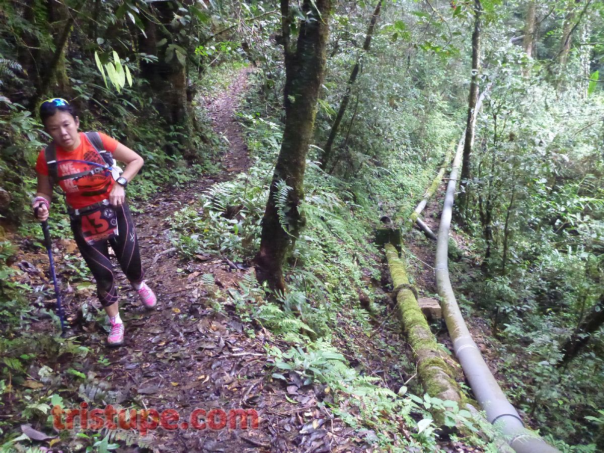
Lucky for us, the marriage was saved by reaching the bottom of the trail where the river runs through. Maze of pipes were seen and i concluded this is where the local draw their water sources from. Mountain river providing sustenance for life. We took a breather here and continued on.
The remaining 3km was not a walk in the park either, as the trail starts to climb up and the trail are partly shared with these 12-inches water pipes...giving us only a foot-space to walk/climb over.
Now, to climb over, go under or squeeze in between?
The Liwagu trail was a many first for wifey...While she is used to run in Kiara, Liwagu colder climate, steeper descent and mossy ground provide a new type of exposure to her. I assured her that the Skechers GoTrail is a very "sure footed shoe" on these terrains and to go forth confidently. I was wearing mine and no issues going up, down, over and under any condition. But i totally understand her holding back.
No gears as important as guts.
Liwagu trail then met with Silau-silau trail to the Park HQ. Apparently, after the race, i found out many people got lost in this portion of the trail and end up going in circle.
This one easier clearing...just right under.
The last portion of the trail was easy with clear route that if you read the instruction...no way to "get lost". :)
Relief that the trail now wider than two feet
We got into CP3 and by then, we bumped into a number of participants. The Liwagu-Silau-Silau trail took me and wifey a cool 2.5hours. We were told the fastest team got it done in an hour with most averaging 2.5hours. At CP3, we attended to a blister forming on wifey's right toe. This is due to her putting more pressure on the tip of the toe while going down. Imagine you clenching your toes like a fist while constantly moving down steep descent. If the fear doesn't give you blisters in your heart, the rubbing between your toes and the shoe will. Remember - if is IMPORTANT to arrest these blisters from forming. The 10minutes stop will help to make sure the next 10hours will be bearable!
Out of the Park HQ and on towards Bundu Tuhan!
We continued on after saying goodbye to Doc Dev and Pam (which are on the way out to another CP). We went around the Park HQ, avoiding the steep climb on one side by walking a bit further passing the Park's Hostels. Yes, local knowledge helps. By then, it was already almost 8hours of walking/hiking/jogging and we aren't even half way yet. Sabah Adventure at that point of time, will prove to be a challenge once daylight ends. We started to walk a bit faster, maintaining a decent 12-15min/km pace. The hike up Layang-Layang via Mesilau and the fear-gripping Liwagu took out pretty much energy that we had.
OK, going against traffic at this road is silly, best to follow traffic but on the left most side near barrier
My day's nutrition was planned for 10-hours. Yes, that was how much confidence I have for us to get the day's mileage done. Luckily, after Hour 4, I've reduced my Perpetuem Solids to just one tablet/hour and continued to take 1 serving of Gel/hour. As the weather was really kind and the sun did not burn down on us, I reduced my Endurolytes from 3-tabs/hour to 2-tabs/hour. I have spare food for emergency and 5 more servings of Heed (in powder form) to last the remaining 20km (at that point, I believe the distance is still...34km as shared by Race Director)
Walking back to KK is another Challenge itself...One day, maybe.
It was a short 2km walk from Park HQ to the turn off at Bundu Tuhan. A pleasant walk like it was at Cameron Highland. Cool and nice.
Good Looking and Pretty.
The view, however, was breathtaking. We were on higher ground and we could see the valleys below. Somehow, I know we will be going down those valleys...It was not a nice feeling, but heck, the other 99 participants has to do it, so do we.
Playground for Day1
We passed a few shops by the road. Fruits and food were sold at a very very reasonable price. Locally grown produce, literally from the back of their home, were sold at price that will make any wet wholesale market shy. For example, a pumpkin at almost 5kg weight...for RM8?
Impressed. But no, we can't buy it back.
As we approach Bundu Tuhan junction, we witnessed a "mist attack". It was something I see on time lapse view on national geographic, but that day, I saw it life...and you can hear how excited I was.
A little bit more on Hammer Nutrition that I was taking. I've requested for my gel to come with caffiene. To reduce rubbish generation, Hammer has offered me a 26 servings bottle. Each serving of Espresso Gel comes with 50mg of caffiene. I am a happy man. Really.
The Gel dispenser were given by Hammer too. I've been looking for these far too long
Walking down the road to find Jalan Kinasabaran was easy if you pay enough attention to instruction and keep your eye on the look out for route marker. Even with that, I was told a few people and team missed it and went straight to Bundu Tuhan...and the coming up back was a big exercise itself.
No way you miss this...and the red-white tape on the road sign...well unless...(fill in the blank)
We were back to gravel road, estimated about 1.5km to CP4. Pretty fast covered and after reporting at CP4, we went on towards CP5. A longer route on gravel road that never ends.
Gonna be fun
Birthday cake - that was what the girl was holding.
Of which the journey will continue towards finding CP5, which lies somewhere below the valley. We all know the finishing point is on top of a hill. The sinister smile and evil laugh of the race organisers echoed in my head. Haha! Enjoy some photos taken along the 5km from the Junction to CP5.
Friendly locals. They smile and greet you when you bump into them.
See that white building between the two hill valley? That's the junction at Bundu Tuhan from the main road you saw in the Mist video earlier. Yes, that is how 2km straight line looked like...and how much we had descended...
Local boy. Where a toy car is all he need for company
Passing some plantation. These are veges mostly.
A church. Local community church.
Development has slowly encroach the traditional way of doing things
The simple life where a shack is a home.
We were back on sealed road! Yay!
We know we were approaching CP5 when the race instruction told us to stay off the highway. We reached Kampung Kinasabaran and now is to find CP5. I know a few racers too, got lost here. ALl you really need to do is to read and re-read the instructions. When we are tired, we tend to read and see only things we want to see...and that is when we can end up lost and away from the direction we want to go.
The route is the road on the left of the photo. Staying off the main road!
A homestay
CP5! CP5!
From CP5, we know if we can get to CP6 before night fall, the race director WILL let us continue and not cut us off due to technicality (and take time penalty). I know wifey want this as much as I wanted it. So, we picked up the pace a little. By then, My Garmin Fenix already showed we moved close to 30km...I then know the race will definitely be in access of 34km. But who is counting in an Adventure race?
Entrance to the farm. Right side ladder is for human. Cows can't climb ladder
When the race director say "steep" they meant it. Here is two video of how it was moving down to find CP6.
In this video, you can see what we saw walking down the farm. The sight, i tell you...breathtaking. The route to CP6...however...daunting!
CP6? All the way across, it's somewhere the "m" in my watermark is in the photo above
Of course, not everyday you will be able to walk past a proper farm. Not counted those you seen in Cameron commercial plantation. These are mainly for local area consumptions.
Sawi. Mustard Leaves
Making fun. Told wifey that the route is wider than Liwagu. Won't fall over the side of the trail
trying to look interested. We are to go all the way down to the bottom of the valley this way.
Tiredness seeps in and it was evidence as Wifey has never raced beyond 7hours in her life. For her to be doing this at almost 10hours was already awesome. Something simple like coming down a 1m drop was a task.
I feel the pain
We reached CP6 right before 6:30 and the sun set soon after we geared up with the headlights. The condition became almost pitch black in 20minutes. We were to go down a plantation guided only by red-white tape marker tied to bamboo sticks at about 20m interval (i know because I look and spot them). I was again told, many got lost at the plantation. Hmm...
In The Dark
Even the camera high ISO fail to give a steady shot
This is with flash, high ISO and the area behind wifey were pitch black too!
I was told the view around this area was awesome. Well those of them that past this CP in brightness enjoyed it. How it looked in daylight? Here. From Kam's camera.
This. In daylight. Photo from Kam.
How about from the earlier racer's perspective?
This. By Nasier.
So, what did we saw?
Haha! Yes, this.
And this...
Is that a building? Or a cemetery? Or a big monsoon drain catch? Dayem!
Hydration and fuelling become more important. Morale was low. Body was tired. We continued to stick to plan and eat and hydrate while we can. Wifey was really tired.
Solids - Strawberry Vanilla for the sweetheart.
We managed to cross the small stream at the bottom of the valley as directed by the Race Organisers safely. Many first for wifey on Day 1. But the stream crossing in the dark was a blessing - because she can't see anything other than what the headlight pointed! We got out of the stream, hike up past some one's backyard (literally) and headed to a sealed road. Next is to find a school and take a right to head towards Zen Garden. CP7 is not far away.
The School. SK Kundasang. Look it up to see where it is on the Map.
Zen Garden Entrance! Yes!
We made a mistake going up Zen Garden and bumped into a 4wd we thought was the race marshall. It was a group of local men...drinking. Reeking of alcohol, one of them approach us as I called out to them. I knew that was a mistake. I noticed wifey started to move backward slowly and i spoke softly and nicely to them...luckily, those I encountered were "polite drunk". Believe me when I say he even pointed the right way when I asked for direction to the Kundasang National Camp. A Buddy That Sticks With You In The Dark Is A Buddy To Keep
We walked a bit to CP7 and saw Bandit sitting down by the side. Yes, it was dark, and well, it was unmistakeably him with the gears.
Not on purpose, I was asking where we heading and they both pointed same direction
Apparently, Bandit told us that he got cut off at CP5 after being chased by dogs. Race director decision to end his race technically and for him to take a 4.5hours penalty for missing CP5 and CP6. A handful of racers were cut off at CP5 and had to take time penalty for that. He has a choice to go back to Mesilau...but Bandit, being him, requested that he is transferred to CP7, radioed the marshall to find out where me and wifey was, and waited for us so we can finish the race (Day 1) together. Sweet!
Starting the ascent to Hotel Perkasa. It was a walk up two contour lines over 2km, that's at least 10degree gradient all the way.
As usual, with company around, we started to talk cock and take lights of the matter.
We raced for more than 12 ours at that point of time and the end of the race was very near. The last 1km was the toughest as the gradient seems to be more acute than the first 1km from CP7. It shot up literally. We then saw lights at the end of the road and Marshalls shouting for us. YES! We made it! Day 1 took a long 12hours 48minutes and 44 seconds. It covered 40km on my Garmin Fenix and 34km on Wifey's 910xt. I found out the disparity was that the Fenix calculate the vertical distance and not just point to point on the map. Make sense if you ask me.
Oh-So-Awe-Some feeling!
The tiredness went away as we checked into the van to bring us back to Mesilau. You can see just how proud of wifey finishing Day 1 of the race! Champion!
Thumbs up!
Race Map.
9 sets of instruction to get you there safely. Keyword? READ!
Summit Trail Mesilau - Layang-Layang
CP2 to CP3, now don't go get lost
With Day 1 finished and getting back to base camp at 9.30pm, it was a short rest before preparing for Day 2 in less than 8 hours time. This is Sabah Adventure Challenge. Next : Day 2 and Day 3 coming up soon!
Thanks for write up.. lots of details ..great photos and loves the video commentary. The timbohan downward descent part reminds me of Climbathon 2011. Really felt the incredible effort to do the trail from the write up.
Yes. The timpohon route was Climbathon route for 25 years. :) Having attempted it 3 times myself, it is not a surprise for me or wife. Byt the Mesilau trail..that was worth the hike.
Wow, nicely written . Awesome weather too. Really looking forward for the next report. Well done Bro, and to your wife too considering this is her first of such race. Good Job.


BEST
ReplyDeleteSYOK!
DeleteYour wife look so Gung-Ho in the last pic. Like saying "Bring on Day 2 and 3!!!" :)
ReplyDeleteBetter not piss her bro. :D
DeleteAll hail Aileen Har!! Well done the both of you..
ReplyDeleteAnd you too bro. Achievement and you beat the daylight!
DeleteThanks for write up.. lots of details ..great photos and loves the video commentary. The timbohan downward descent part reminds me of Climbathon 2011. Really felt the incredible effort to do the trail from the write up.
ReplyDeleteChee H.
Yes. The timpohon route was Climbathon route for 25 years. :) Having attempted it 3 times myself, it is not a surprise for me or wife. Byt the Mesilau trail..that was worth the hike.
DeleteWow, nicely written . Awesome weather too. Really looking forward for the next report. Well done Bro, and to your wife too considering this is her first of such race. Good Job.
ReplyDeleteI am writing Day 2 and 3 now. So much in memories and so little time. Hang on there. Will hopefully done by this Friday.
DeleteGreat stuff. Keep it up!
ReplyDeleteThank you!
Deletebravo, tristupe and your wifey.
ReplyDeleteThank you!
Delete